"A land flowing with milk and honey..."
Shemot (Exodus) 3:8
Eretz Israel (Land of Israel) is a small, narrow, semi-arid piece of land on the southeastern coastline of the Mediterranean Sea. It entered history some 35 centuries ago when the Jewish people forsook their nomadic way of life, settled in the Land and became a nation. Over the years, the Land was known by many names - Eretz Israel; Zion, one of Jerusalem's hills which came to signify both the city and the Land of Israel as a whole; Palestine, derived from Philistia, and first used by the Romans; the Promised Land; and the Holy Land, to mention but a few. Mountains and plains, fertile fields and deserts are often minutes apart.
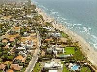 The coastal plain runs parallel to the Mediterranean Sea and is composed of a sandy shoreline, bordered by stretches of fertile farmland extending up to 25 miles (40 km.) inland. In the north, expanses of sandy beach are occasionally punctuated by jagged chalk and sandstone cliffs which drop sheerly to the sea.
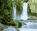
Several mountain ranges run the length of the country. In the northeast, the basalt landscapes of the Golan Heights, formed by volcanic eruptions in the distant past, rise as steep cliffs overlooking the Hula 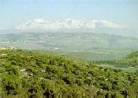 Valley. The hills of Galilee, largely composed of soft limestone and dolomite, ascend to heights ranging from 1,600 to 4,000 feet (500 to 1,200 m.) above sea level. Small perennial streams and relatively ample rainfall keep the area green all year round.
The Jezreel Valley, separating the hills of Galilee from those of
Samaria, is the land's richest agricultural area. The rolling hills of Samaria and Judea present a mosaic of rocky hilltops and fertile valleys, dotted with age-old silver-green olive groves. The terraced hillsides, first developed by farmers in ancient times, blend into the natural landscape.
Valley. The hills of Galilee, largely composed of soft limestone and dolomite, ascend to heights ranging from 1,600 to 4,000 feet (500 to 1,200 m.) above sea level. Small perennial streams and relatively ample rainfall keep the area green all year round.
The Jezreel Valley, separating the hills of Galilee from those of
Samaria, is the land's richest agricultural area. The rolling hills of Samaria and Judea present a mosaic of rocky hilltops and fertile valleys, dotted with age-old silver-green olive groves. The terraced hillsides, first developed by farmers in ancient times, blend into the natural landscape.
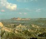
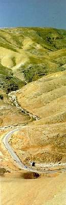 Further south, the Negev becomes an arid zone characterized by low sandstone hills and plains, abounding with canyons and wadis in which winter rains often produce flash floods. Continuing southward, the region gives way to an area of bare craggy peaks, craters and rock-strewn plateaus, where the
climate is drier and the mountains are higher. Three erosive craters, the
largest of which is about 5 miles (8 km.) across and 21 miles (35 km.)
long, cut deeply into the earth's crust, displaying a broad range of
colors and rock types. At the tip of the Negev, near Eilat on the Red Sea,
sharp pinnacles of gray and red granite are broken by dry gorges and sheer
cliffs, with colorful layers of sandstone glowing in the sunlight.
Further south, the Negev becomes an arid zone characterized by low sandstone hills and plains, abounding with canyons and wadis in which winter rains often produce flash floods. Continuing southward, the region gives way to an area of bare craggy peaks, craters and rock-strewn plateaus, where the
climate is drier and the mountains are higher. Three erosive craters, the
largest of which is about 5 miles (8 km.) across and 21 miles (35 km.)
long, cut deeply into the earth's crust, displaying a broad range of
colors and rock types. At the tip of the Negev, near Eilat on the Red Sea,
sharp pinnacles of gray and red granite are broken by dry gorges and sheer
cliffs, with colorful layers of sandstone glowing in the sunlight.
The Jordan Valley and the Arava, are part of the Syrian-African Rift which split the earth's crust millions of years ago. Its northern stretches are extremely fertile, while the southern portion is semi-arid.
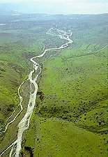 The Jordan River, flowing from north to south through the rift, descends over 2,300 feet (700 m.) in the course of its 186 mile (300 km.) route. Fed by streams from Mount Hermon, it runs through the fertile Hula Valley into Lake Kinneret (Sea of Galilee) and continues winding through the Jordan Valley before emptying into the Dead Sea. While it swells during the winter rainy season, the river is usually quite narrow and shallow.
Lake Kinneret, nestled between the hills of Galilee and the Golan at 695 feet (212 m.) below sea level, is 5 miles (8 km.) wide and 13 miles (21 km.) long.
The Jordan River, flowing from north to south through the rift, descends over 2,300 feet (700 m.) in the course of its 186 mile (300 km.) route. Fed by streams from Mount Hermon, it runs through the fertile Hula Valley into Lake Kinneret (Sea of Galilee) and continues winding through the Jordan Valley before emptying into the Dead Sea. While it swells during the winter rainy season, the river is usually quite narrow and shallow.
Lake Kinneret, nestled between the hills of Galilee and the Golan at 695 feet (212 m.) below sea level, is 5 miles (8 km.) wide and 13 miles (21 km.) long.
The Arava begins south of the Dead Sea and extends to the Gulf of Eilat, on the Red Sea. The average annual rainfall is less than one inch (25 mm.) and summer temperatures soar to 104 degF (40 degC). The sub-tropical Gulf of Eilat, noted for its deep blue waters, coral reefs and exotic marine life, lies at the southern tip of the Arava.
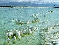 The Dead Sea, the lowest point on earth at about 1,300 feet (400 m.) below sea level, lies at the southern end of the Jordan Valley. Its waters, with the highest level of salinity and density in the world, are rich in
potash, magnesium and bromine, as well as in table and industrial salts.
The Dead Sea, the lowest point on earth at about 1,300 feet (400 m.) below sea level, lies at the southern end of the Jordan Valley. Its waters, with the highest level of salinity and density in the world, are rich in
potash, magnesium and bromine, as well as in table and industrial salts.
 The climate ranges from temperate to tropical, with plenty of
sunshine. Two distinct seasons predominate: a rainy winter period from
November to May; and a dry summer season which extends through the next
six months. Rainfall is relatively heavy in the north and center of the
country, with much less in the northern Negev and almost negligible
amounts in the southern areas. Regional conditions vary considerably, with
The climate ranges from temperate to tropical, with plenty of
sunshine. Two distinct seasons predominate: a rainy winter period from
November to May; and a dry summer season which extends through the next
six months. Rainfall is relatively heavy in the north and center of the
country, with much less in the northern Negev and almost negligible
amounts in the southern areas. Regional conditions vary considerably, with
 humid summers and mild winters on the coast; dry summers and moderately
cold winters in the hill regions, hot dry summers and pleasant winters in
the Jordan Valley; and year-round semi-desert conditions in the Negev.
Weather extremes range from occasional winter snowfall at higher
elevations to periodic oppressively hot dry winds which send temperatures
soaring, particularly in spring and autumn.
humid summers and mild winters on the coast; dry summers and moderately
cold winters in the hill regions, hot dry summers and pleasant winters in
the Jordan Valley; and year-round semi-desert conditions in the Negev.
Weather extremes range from occasional winter snowfall at higher
elevations to periodic oppressively hot dry winds which send temperatures
soaring, particularly in spring and autumn.
Copyright © 1995 - 2024 Ahavat Israel. All rights reserved.