In Biblical times, the Golan Heights was referred to as "Bashan." The Bashan Region was promised to the Patriarch Abraham and the people of Israel on the occasion of the "Brit Ha (Covenant of) Betarim" (Genesis 15). The word "Golan" derives from the biblical city of "Golan in Bashan," (Deuteronomy 4:43, Joshua 21:27). The area was assigned to the tribe of Menashe (Joshua 13:29-31).
In early First Temple times (953-586 BCE), the area was contested between the northern Jewish kingdom of Israel and the Aramean kingdom based on Damascus. King Ahab of Israel (reigned c. 874-852 BCE) defeated Ben-Hadad I of Damascus near the site of Kibbutz Afik in the southern Golan (I Kings 20:26-30), and the prophet Elisha prophesied that King Jehoash of Israel (reigned c. 801-785 BCE) would defeat Ben-Hadad III of Damascus, also near Kibbutz Afik (11 Kings 13:17).
In the Second Temple period, late 6th and 5th centuries BCE, the region was settled by returning Jewish exiles from Babylonia. In the mid 2nd century BCE, Judah Maccabee and his brothers came to the aid of the local Jewish communities when the latter came under attack from their non-Jewish neighbors (I Maccabees 5). Judah Maccabee's grandnephew, the Hasmonean King Alexander Jannai (reigned 103-76 BCE) later added the Heights to his kingdom.
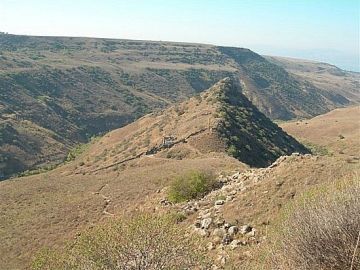
Jewish settlement in the central Golan existed continuously since then for a period of 700 hundred years. The district capital was Gamla, which was the area's last Jewish stronghold to resist the Romans during the Great Revolt, falling in the year 67. Despite the failure of the revolt, Jewish communities on the Golan continued, and even flourished, during the Talmudic period. The remains of no less than 25 synagogues from the period between the revolt and the Islamic conquest in 636, when organized Jewish settlement on the Golan came to an end, have been excavated. A basalt lintel stone was found in the village of Dabura, north of Qazrin, with the engraved inscription, "This is the Beit Midrash (religious school) of Rabbi Eliezer Hakapar". This is the only archeological evidence for the existance of "Beit Midrash" from the Talmudic period.
The Tosefta of "Braitat hatehumin" includes the Golan and Transjordan in the holy borders of the land. It obligates the Golan with the Mitzvot imposed on the land: Trumot, Ma'asrot and Shevi'it. The Jerusalem Talmud lists seven Jewish towns in the Suseita region, some of whose names have been preserved to this very day: Nob, Hissafiya and Kfar Harub, all in the Suseita region. Permanent settlements in the Golan disappeared with the Arab conquest, and it became a land of nomads and brigands.
In The 19th Century, because of these ancient roots, the heads of the Zionist Movement and the people of the old cities of Safed and Tiberias viewed the Golan being part of the effort of resettling the land of Israel as self understood, and made every effort to settle it. The Jewish presence on the Golan was renewed in 1886, when the "Bnei Yehuda" society of Safed purchased a plot of land in Ramataniya village in central Golan, four kilometers north-west of the present day religious moshav of Keshet. They named their settlement "Golan BeBashan" and settled there for about a year.
In 1887, they purchased lands between the modern day Bnei Yehuda and Kibbutz Ein Gev. This community survived until 1920, when two of its last members were murdered in the anti-Jewish riots which erupted in the spring of that year. In 1891, Baron Rothschild purchased approximately 18,000 acres of land about 15 km east of Ramat Hamagshimim, in what is now Syria. First Aliyah (1881-1903) immigrants established five small communities on this land, but were forced to leave by the Turks in 1898. The lands were farmed until 1947 by the Palestine Colonization Association and the Israel Colonization Association, when they were seized by the Syrian army. Most of the Golan Heights were included within Mandatory Palestine when the Mandate was formally granted in 1922, but Britain ceded the area to France in the Franco-British Agreement of 7 March 1923. The Golan Heights became part of Syria upon the termination of the French mandate in 1944.
Following the 1948-49 War of Independence, the land was seized by the Syrian government. The Syrians built extensive fortifications on the Heights, from where they systematically shelled civilian targets in Israel and launched terrorist attacks. 140 Israelis were killed and many more were injured in these attacks between 1949 and 1967. Heavy property damage was also inflicted. The Golan Heights were liberated by the IDF on June 10, 1967, the last day of the Six Day War.
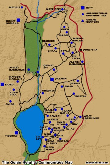
The renewal of the Jewish presence on the Heights almost immediately followed the war. Kibbutz Merom Golan was founded in July 1967, at the initiative of kibbutzim in the nearby Upper Galilee and Hula Valley. By 1970, there were 12 Jewish communities on the Golan. On 6 October 1973, Syrian forces attacked across the 1967 cease-fire line and made their greatest gains in the central Golan, almost reaching the escarpment, before being pushed back beyond the 1967 line by the main Israeli counter-attack, which began on the morning of 8 October. A few more years passed, and the Golan was settled from the north to the south, by people of all settlement movements. At present there are 33 communities on the Golan Heights, including the city of Qatzrin.
Geology, Geography and Natural History
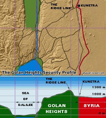
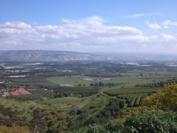
The Golan Heights, are actually composed of two geologically distinct areas divided by Nahal Sa'ar: the Golan Heights proper, about 1,070 sq. km., and the slopes of the Mt. Hermon range, about 100 sq. km. While the Mt. Hermon range is mostly limestone, the Golan Heights proper is mostly basalt and other types of volcanic rock, forming a plateau that drops off to the west, to the Jordan River and Lake Kinneret, and to the south, to the Yarmouk River. The plateau is crossed by a number of seasonal streams which run through valleys and flow west into the Jordan or the Kinneret. The Golan overlooks the Hula Valley, Israel's richest agricultural area.
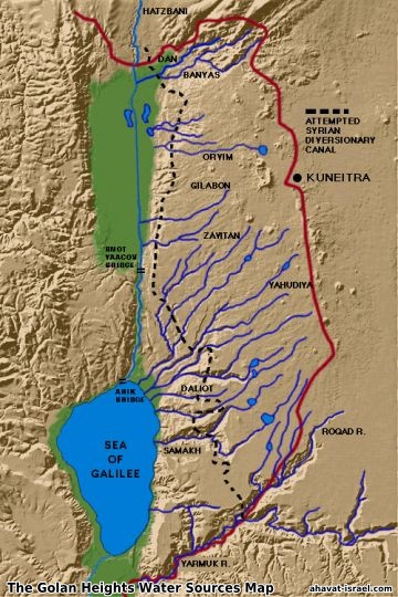
The northern Golan has double the average rainfall of the southern Golan, and often receives snow in the winter, as does the Mt. Hermon area. Hydrologically, nearly the entire Golan lies within the Lake Kinneret catchment basin, which supplies 30% of Israel's water requirements. Two of the Jordan River's main sources, the Dan and the Banias Rivers, rise on the slopes of Mt. Hermon, in addition to many seasonal streams that rise on the Heights and flow into the Lake, either directly or via the Jordan. In 1964, Syria sought to divert the sources of the Jordan and prevent their waters from reaching Israel, provoking a series of border incidents. The Syrian plan was ultimately thwarted by IDF operations in the spring of 1965.
In ancient and classical times, the Golan was heavily forested (see Ezekiel 27:5-6). Today, small remnants of these forests survive near Odem and Mt. Avital in the north, and near Yehudiya in the central Golan. Half of Israel's mammal and reptile species, and all of its amphibians, can be found on the Heights.
The Golan Heights Economy
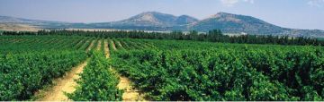
The economy of the Golan Heights is based on both agriculture and industry, including tourism. 8,100 hectares of land are under cultivation, producing a wide variety of crops, including wine grapes. A further 46,575 hectares are dedicated to natural pasturage, supporting 15,000 head of cattle and 5,000 sheep, for both meat and dairy production. The Golan's dairy cattle produce approximately 60 million liters of milk per year. The are approximately 30 industrial enterprises on the Golan, mostly based in the Katzrin Industrial Zone.
There is a substantial tourist infrastructure on the Golan, including the Mt. Hermon ski slopes, archaeological sites, hotels, restaurants, bed-and-breakfast guest room facilities in many communities, and three Society for the Protection of Nature Field schools. There are also facilities for jeep and bicycle tours, as well as horseback riding. Israel has established 13 nature reserves totaling 24,908 hectares on the Heights. The Golan Archaeological Museum is located in Katzrin.
The Golan Heights Law
On 14 December 1981, the Knesset passed The Golan Heights Law by a vote of 63-21. Its first paragraph states: "The law, jurisdiction, and administration of the state shall apply to the Golan Heights." Following the passage of this law, the Israeli military administration on the Heights was dismantled and regular civilian authorities were established. The Golan's Druze residents are permitted to maintain their previous citizenship, but were given the option of becoming full Israeli citizens.
Mount Hermon
Mount Hermon is the most northern point of Israel. Mount Hermon is the highest point in Israel, it's highest peak gets up to about 2,224 meters above sea level. Mount Hermon is important because of it's strategic advantage. The highest point on Mount Hermon is home to sophisticated and latest technology Radar and Tracking systems of the IDF. A good view of Mount Hermon can be had at Brehat Ram (Ram Pool), a small, shallow lake in the crater of a dormant volcano. The lake has some fish, and in the summer it is also a pleasant recreational area for swimming and picnicking.
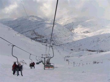
Mount Hermon is home to the only skiing site in Israel. In winter, Mount Hermon is covered with snow, and packed with thousands of Israelis coming to see and ski the only snow they have in Israel. The skiing site is run by the only Jewish settlement on the Mountain: Neve Ativ. The vertical drop in the Mount Hermon skiing site is 620 meters. The longest run is more than a mile. A lift for non-skiers goes to the summit and affords a spectacular view of the surrounding area.
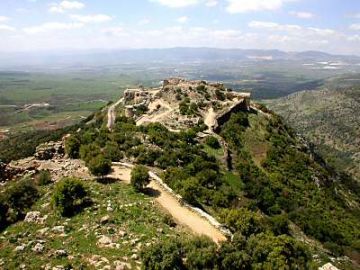
Nimrod's Castle
Another interesting archaeological site is Mivzar Nimrod, a 12th century Crusader castle that allowed its ruler to control traffic between Lebanon and Tiberias and the Jordan Valley. The fortress exchanged hands between Christians and Muslims for some time and was held for some time by a radical Muslim sect known as the Hashishin. This group was known for smoking hashish and murdering their enemies. The word "assassin" is derived from this sect.
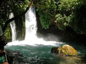
Driving through the Golan, you see beautiful mountains, rocky hillsides, green valleys and wild flowers. You can also find spectacular waterfalls off the main roads near Gamla and below Nimrod's Castle. Of course the falls are only in full force during winter and early spring. By summer, many of them dry up.
The Upper Galilee
The Hula Valley was once a marshland. Israel drained it to eradicate malaria and make room for more people to live and farm after independence. The Hula Nature Reserve offers places to see birds and other animals. You can also go kayaking nearby in the Jordan River. In the upper Galilee, you'll find a number of interesting towns and villages. The largest is Kiryat Shmona. The town takes its name, which means "Town of the Eight," from the heroic Zionist, Joseph Trumpeldor, who, together with seven other defenders, was killed in a last-ditch battle against Arab marauders at the nearby settlement of Tel Hai in 1920.
Israel's northernmost village, at the border of Lebanon and foot of Mt. Hermon, is Metulla. This picturesque town was established in 1896. Just west of the town is the "Good Fence," a border crossing where some Lebanese are allowed to enter Israel for work and medical care. A little more than a mile from Kiryat Shmona is Tel Dan and the Dan River, one of the three main sources of the Jordan River. Today, the area is a nature reserve. Nearby Beit Ussishkin is a museum that tells the story of the Hula Valley and the Hermon.
Returning to the Golan has reconnected us to our Jewish legacy in this region and to the long history of the Jewish people that lived on the Golan. From G-d's promise to Abraham, through the dispersion of the twelve tribes of Israel, the thriving village of Gamla dating back to Temple times, significant Jewish presence during the Talmudic period, and to the settlement of Bnei Yehuda established on the Golan in the beginning of the Zionist movement at the end of the 19th century, connects the Jewish people with the Golan for over 3,000 years.

Since 1967, a vibrant reality has been created on the Golan that can set an example to every other region in Israel. The establishment of 33 communities, a developed economy, and prosperous tourism are only examples of what has been achieved. Famous tourism sites that attract over 2 million visitors a years, are spread all across the Golan from the ski resort on the Hermon Mountain in the north to the hot water springs in Hamat Gader in the South. In between, canyons with white water springs, the seashores of the Eastern Kinneret, and impressive historical remains like Gamla, Qatzrin, and Nimrod's Castle can be found.
Copyright © 1995 - 2024 Ahavat Israel. All rights reserved.